Background
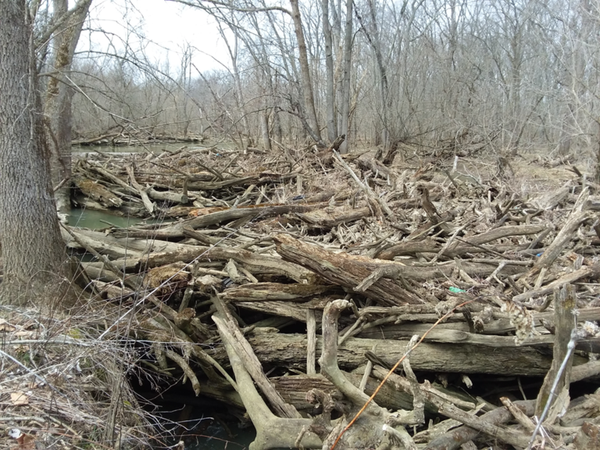
In 2017, the Union Soil and Water Conservation District (SWCD) was contacted by the Union County Commissioners and Paris Township Trustees to investigate recurring flooding in Paris Township. Upon investigation, an enormous logjam was discovered in Mill Creek. It was 1,600 feet long, 80 feet wide, and 5 feet tall at its highest point.
A committee was formed to study this issue and they found many other logjams along the length of the creek. They realized that a project to remove all of these logjams would be an incredibly large undertaking that would require funding, manpower, and detailed planning. Multiple public agencies pitched in to fund a three-year position that would research Mill Creek and inventory the number of logjams and dead trees along the banks. This individual was hired in 2018 and completed their work in 2021.
Union County secured funds through the American Rescue Plan Act (ARPA) to cover all costs of removing these log jams. In 2023, work began on a petition process that was required to formally begin the work and cover long-term maintenance after the log jams were removed. This was done in addition to an outreach campaign to let the public know about this project and what it entails. The purpose of this website is to help educate the public about this project and it contains the same information that will be covered at our public open houses in October.
Who's Involved
What's the Problem
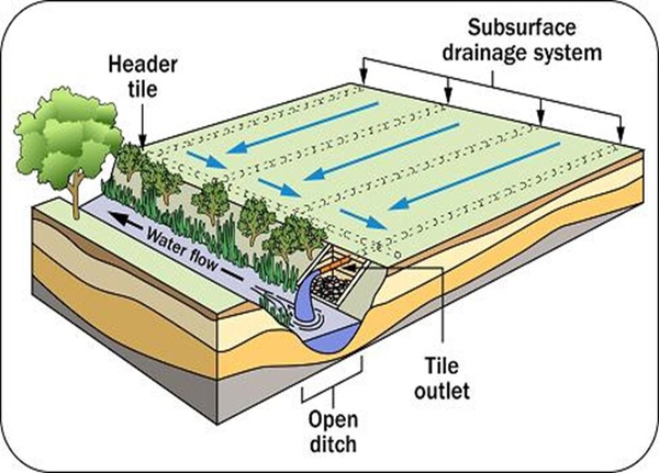
When it rains, the excess water is collected in underground pipes that flow to nearby creeks, rivers, or ditches. These waterways are called “outlets” because they receive this outgoing water from our drainage systems. The image below shows how it works.
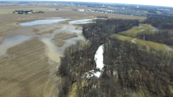
Mill Creek is the outlet for all agricultural, residential, and municipal drainage within the watershed. The log jams act like dams, causing the water in the creek to back up. When water is covering the outlet pipe, water backs up further into the drainage system instead of flowing out of it. This prevents it from working properly. The damming of the creek also reduces the ability of Mill Creek to convey water, which causes the creek to overtop its banks and flood. This flooding has destroyed crops, caused property damage, and even killed trees by drowning their root systems. The image below shows the flooding of a farmer’s field caused by Mill Creek overtopping its banks.
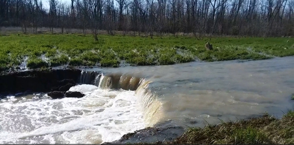
If the water in the creek is not able to travel along its normal channel, it can also start to flow along whatever “the path of least resistance” happens to be. This has caused Mill Creek to start cutting new creek channels through adjacent properties. The image below shows a new creek channel being eroded away on land that used to be flat and dry.
Our goals in removing these logjams are to:
- Improve drainage throughout the watershed.
- Alleviate streambank erosion.
- Minimize re-routing of creek channels.
- Reduce standing water in ag fields / residential properties.
- Minimize crop damage due to flooding.
- Increase recreational use.
What's the Scope
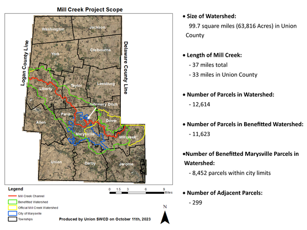
Mill Creek’s “watershed” (the area of land that drains into it) contains about 99.7 square miles (or 63,816 acres) of Union County land. Over 80% of that land is agricultural.
Mill Creek itself is 37 miles in length and flows southeast through Logan, Union and Delaware Counties before it empties into the Scioto River. Of those 37 miles, 33 are in Union County.
In Union County, the Mill Creek watershed contains a total of 12,614 distinct parcels excluding right-of-way. However, only 11,623 of these benefit from the project. This is because 991 parcels drain into a waterway which does not enter Mill Creek until after it crosses into Delaware County. 8,452 of these benefitted parcels are within the corporate limits of Marysville and 299 border Mill Creek. The image below shows the course of Mill Creek (red) and the extent of the benefitted Mill Creek watershed (green).
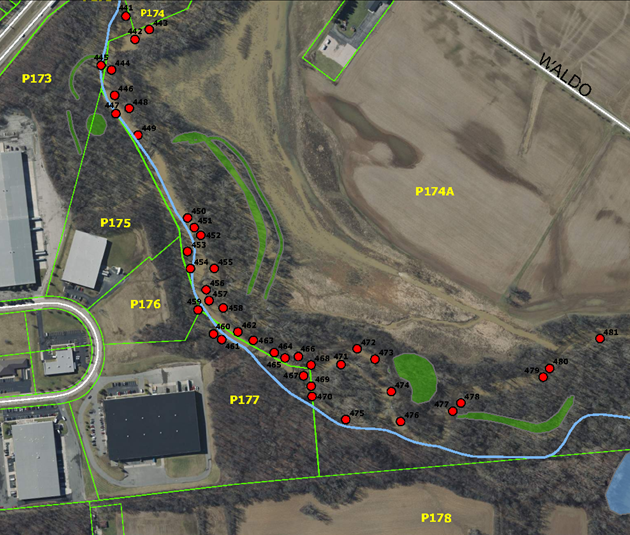
There are currently 759 identified log jams or piles of debris in Mill Creek. Most of these are smaller, but all of them either block a portion of the channel or could grow and do so in the future. The plan is to remove all of them. It is estimated that 50 of these are larger log jams that completely block the channel. Below is an image from the preliminary engineering plans that shows one area with many of these logjams or debris piles.
How Is It Paid For
There would not be a charge to property owners for the construction phase of the project. The construction phase of the project would be paid for by the Union County Commissioners using funds from the American Rescue Plan Act (ARPA) along with the fees collected by the City of Marysville’s stormwater fund (within the incorporated areas of the watershed).
To cover the removal of future logjams, debris, and dead or leaning trees, a maintenance fund would need to be created. To create this fund, approximately 10% of the project construction cost would be divided amongst the acres in the watershed and assessed to property owners in the watershed. After that, the account balance for this maintenance fund would be examined annually. If there are adequate funds remaining for the year’s upcoming work, then no maintenance assessments would be collected. Whenever the maintenance fund is running low, the County Commissioners would determine what maintenance collection is required. This amount would then be divided amongst the acres in the watershed and assessed to property owners in the watershed. This would appear on the tax duplicate as a “special assessment”. The Ohio Revised Code mandates that the minimum assessment is $2.00 per parcel.
The City of Marysville currently collects stormwater fees from residents of the City and is expected to use funds from these fees to cover all costs for properties within the City limits.
Tentative Timeline
View (11/8/2023)
- This is an official public meeting where the public will be presented with information about the project. This is expected to be held during three separate sessions. More information to follow.
1st Hearing (12/20/2023 at 6:30pm)
- This is an official public meeting where the public and the County Commissioners can discuss the project together.
Preparation of Plans and Final Assessments
- County staff will finalize all plans, assessment, and maintenance information, assuming the County Commissioners vote to move forward with the project.
2nd Hearing (9/10/2024 at 6:30pm at 940 London Ave.)
- This is an official public meeting where the public and the County Commissioners can discuss the project together. The County Commissioners may also vote at the end of this meeting on whether to formally approve the project and progress to bidding.
Bidding/Construction/Inspection (Expected end of 2024)
- The County would seek out a company that they would hire to complete the project. Once hired, they would begin the work.
- The contractor would have between 18 and 24 months to complete the project after signing the contract. If the process moved as expected, then the project would likely be completed sometime between August 2025 and January 2026.
More Information
Presentation with more details and pictures
Frequently Asked Questions
Preliminary Engineering Report
Drone Videos
Dean Otworth
Project Engineer
Union County Engineer's Office
(937) 645-3126
dotworth@unioncountyohio.gov
Joe Eads
Drainage Maintenance Supervisor
Union Soil & Water Conservation District
(937) 209-2236
jeads@unioncountyohio.gov
 An official State of Ohio government website.
Here's how you know
An official State of Ohio government website.
Here's how you know