|
|
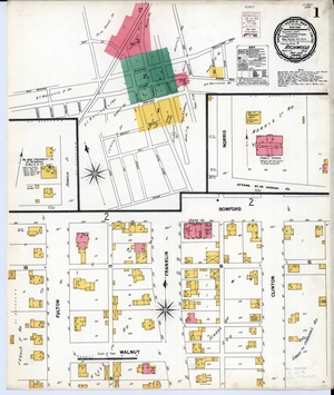
The Sanborn Fire Insurance Maps are a valuable resource for genealogists, historians, urban planners, teachers or anyone with a personal connection to a community, street or building. The maps depict more than 12,000 American towns and cities. They show the size, shape and construction materials of dwellings, commercial buildings, factories and other structures. They indicate both the names and width of streets, and show property boundaries and how individual buildings were used. House and block numbers are identified. They also show the location of water mains, fire alarm boxes and fire hydrants.
In the 19th century, specialized maps were originally prepared for the exclusive use of fire insurance companies and underwriters. Those companies needed accurate, current and detailed information about the properties they were insuring. The Sanborn Map Company was created around 1866 in the United States in response to this need and began publishing and registering maps for copyright. The insurance industry eventually phased out use of the maps and Sanborn stopped producing updates in the late 1970s.
The Sanborn Fire Insurance Map Collection is courtesy of Geography and Map Division of the Library of Congress. For more information in regards to the usage and copyright status of the Sanborn Fire Insurance Maps please see https://guides.loc.gov/fire-insurance-maps/copyright
|
 An official State of Ohio government website.
Here's how you know
An official State of Ohio government website.
Here's how you know